Browse My
Featured Learning Activities
Feeling Through Conflict: A Reflective Activity for Planners and Designers
Feeling through Conflict is a guided reflective exercise I designed as a final project for my masters of planning course "Design and Planning for Community Power". I mobilized my skills in facilitation and storytelling to create an interactive worksheet for planners & designers engaged in anti-oppressive work.

Final Project – Chinatown Public Space Stewardship Strategy
Community engagement is an integral ingredient in planning decision-making. For my final project in my "Communication in the Face of Power" course as a Planning master student, I created a community engagement strategy and poster for a hypothetical project in Vancouver's Chinatown.
UBC Campus and Community Planning: UBC Bird Friendly Design Guidelines for Buildings
Over the last year, I took on a lead role in the writing and research for the updated UBC Bird Friendly Design Guidelines for Buildings. Through research of academic studies and best practice review of municipal guidelines across North America, the update promotes cost-effective and co-beneficial strategies to designers.
Research Abroad with TUDarmstadt: Seeing Soundscapes
In Summer 2019, I had the very enriching opportunity to collaborate on urban design research at Technische Universität Darmstadt, Germany as a visiting research student. I conducted a study to examine the relationship between soundscapes, urban design, and mental health and produced a research poster to illustrate my findings.
UBC Campus and Community Planning: The Green Building Action Plan
From Fall 2017-2018, I had the very exciting and unique opportunity to participate in writing and researching the new UBC Green Building Action Plan (GBAP) for UBC Campus and Community Planning. The GBAP outlines goals, targets, and actions to advance academic and residential buildings at UBC towards making net positive contributions to human and natural systems by 2035.
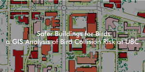
Final Project – Safer Buildings for Birds: a GIS Analysis
Buildings are the main anthropogenic cause of death for birds in cities, with approximately 16 to 42 million deaths in Canada each year, and around 10,000 deaths at UBC. To investigate this issue as a final project in my Advanced Issues in GIS class, I created a model to identify core institutional buildings of high bird collision risk at UBC. The project aims to recommend UBC operational staff where to target bird friendly design retrofits.
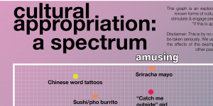
Final Project – Cultural Appropriation as a Spectrum
In order shed light on the complexity of cultural appropriation, I worked on a group project to present a variety of commonly discussed examples from popular media and daily life as a spectrum. Through the project, we hope to engage people to think beyond "is this appropriation?" to "if this is appropriation, who benefits and who doesn't?"