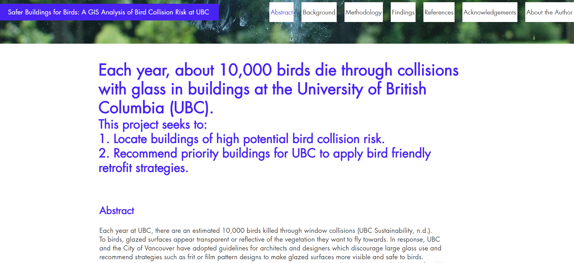
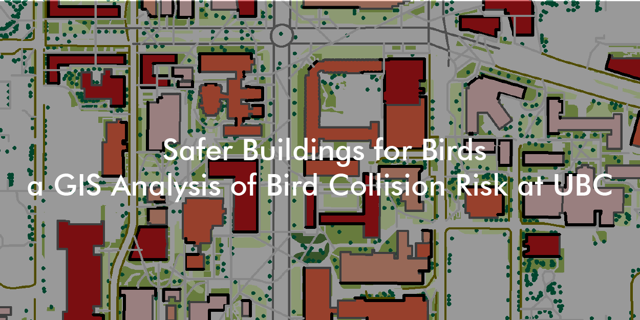
Buildings are the main anthropogenic cause of death for birds in cities, with approximately 16 to 42 million deaths in Canada each year (Machtans et al. 2013), and around 10,000 deaths at UBC. To investigate this issue as a final project in my Advanced Issues in GIS class, I created a model to identify core institutional buildings of high bird collision risk at UBC.
The full report is in the form of a website and discusses:
- present research on the issue and actions at UBC
- my full methodology
- findings and maps
- recommendations for future studies and for planners and operational staff who would like to use my tool.
Background
In my studies, I've always had an interest in the false dichotomy between what is "human" versus "nature" and the intersections of the human-built environment and equally complex world of adaptation and migration of non-human nature. While I had previously come across hawk decals (which are actually proven by research as ineffective for deterring bird collisions) and other bird-friendly interventions in my daily life, until I started to read on the studies happening at UBC, I hadn't realized how big and urgent of a problem this was!
At my job at the Campus and Community Planning department, I've also been working on an update of the UBC Bird Friendly Guidelines, closely reading campus and international research on the issue. I decided to leverage the opportunity as a staff and student to team up with my supervisor, a Landbird Biologist at Environment and Climate Change Canada, and my GIS course. This is my first project with the SEEDS program, which partners students with operational staff such as the UBC Campus and Community Planning department to research issues and advance sustainability on campus. Click to read the report for my second project "Outdoor Public Spaces for Teaching: An Analysis of UBC".
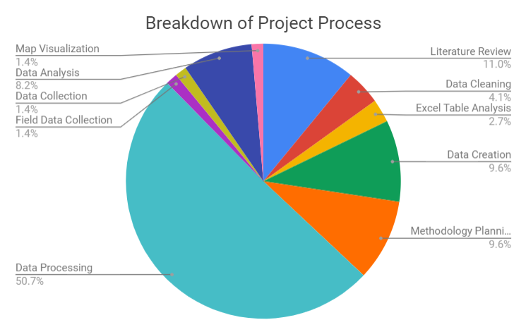
The Process
This was one of the most ambitious projects I've pursued in my undergrad. For one, research in bird building collisions in the Canadian west coast is still emergent and thus severely lacking in data. As well, most research so far had approached the issue from a biology standpoint and this required lots of reading, sorting, and data transformation to spatialize the data.
Finally, the process of independently filling in gaps in knowledge and data led me to investigate in all directions for what I could find. From consulting with contacts I had made through my part-time work at the Campus and Community Planning department to ultimately deciding to conduct my own fieldwork for the very first time! This all required a lot of organization and comprehensive documentation and goal setting.
The project all began with a Google Sheets document.
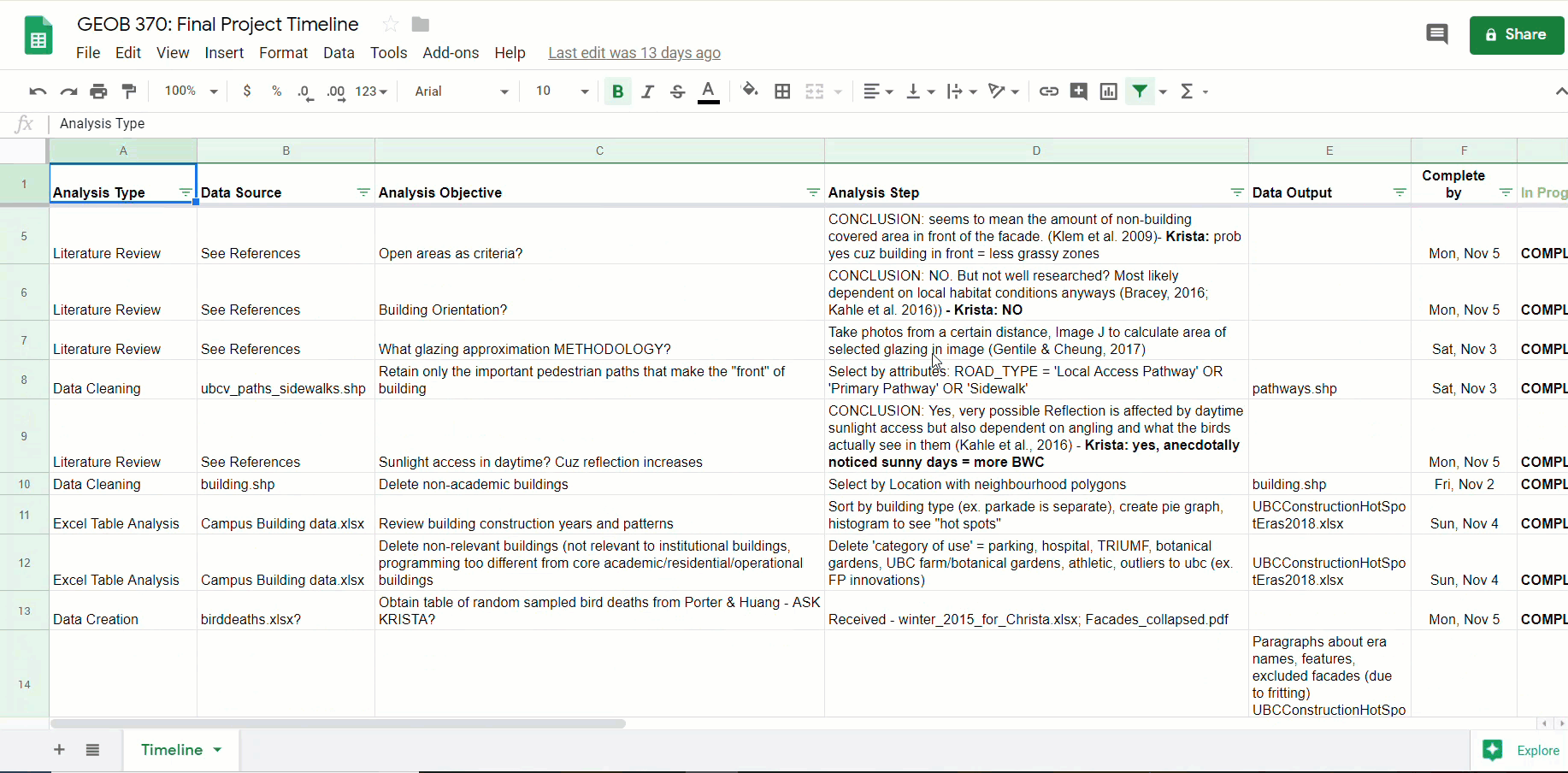
Then followed a process like this:
- Understanding the problem and then identifying appropriate data to represent it through literature review and consulting with experts in Environment and Climate Change Canada and the Campus and Community Planning Department
- Locating data, cleaning, and digitizing it from sources such past bird collision studies, City of Vancouver Data, and Campus and Community Planning department shapefiles.
- Processing and analyzing data to uncover spatial trends in buildings and bird collisions.
- Producing maps, tables, graphs, and other visualizations to narrate my findings.
Advice for Future research
Although this was a short project, it was my first time designing and executing a detailed research GIS methodology, and I went through several phases from initially trying to locate all my data online to devising a field data collection methodology with a sampling design which I could manage within 2 weeks. At times I felt frustrated and anxious for being overly ambitious or not having as much progress as I expected. In the end, I learned many lessons from the challenges of this project; here are my tips for future research:
get creative with your notes
Write notes in many forms such as spreadsheets, sticky notes, and diagrams. Different forms of writing and drawing can bring visibility to different problems as well as the solutions to them.
Consult with expert human help
Some of the most useful data and information isn't available online and comes in the form of expert human knowledge. It's always a good idea to consider emailing, phoning, or directly meeting someone who is engaged with your research problem and would be a potential audience for your findings.
Value the process just as much as the product
Aside from identifying buildings with high bird collision risk, this project was also a valuable opportunity for me to experiment with GIS analysis and methodology.
While the final product is important, there are many transferable skills and lessons to learn from all research. In particular, I found that developing a reflexive lens to my work by being transparent and accountable about the uncertainties and limitations of my project was also a skill I can carry on into future research.
HERE ARE SOME SKILLS I PICKED UP IN SUMMARY
Research Methodology and Analysis:
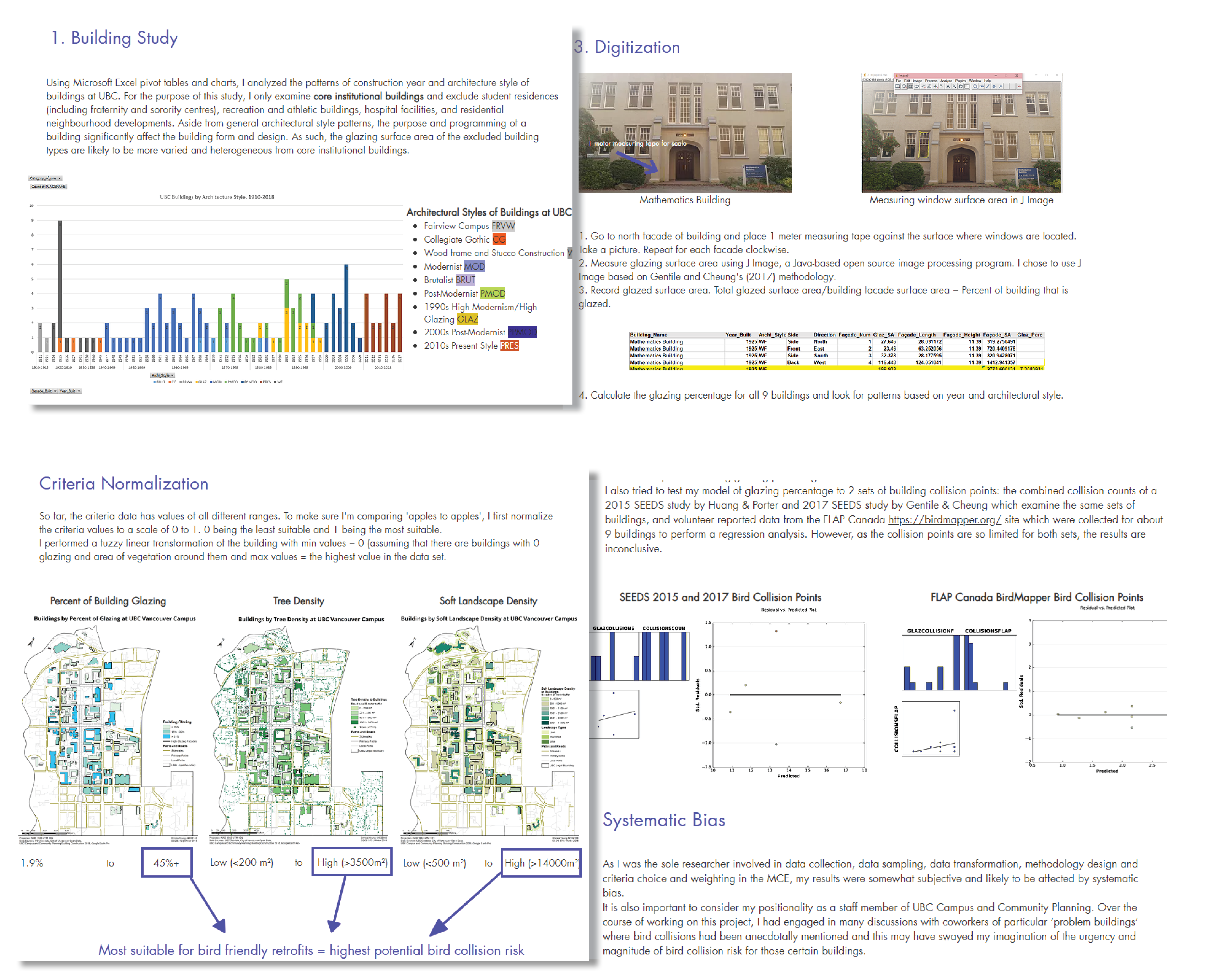
- Performed a Multi-Criteria Evaluation on ArcMap to model bird building collision risk at UBC using the risk factors of building glazing, proximity to vegetation, and access to sunlight.
- Designed a stratified sampling methodology to collect data on building glazing based on a literature review of architectural styles at UBC.
- Conducted an OLS regression analysis to evaluate the statistical performance of my bird collision risk model against bird collision data from past research and FLAP Canada birdmapper.org open data.
Research Presentation:
- Created a Wix site to highlight the problem of bird collisions and showcase project methods, findings, uncertainties, and recommendations for bird friendly design retrofits to lay audiences.
- Designed maps on ArcMap to visualize UBC building and landscape characteristics such glazing percentage, soft landscape type, trees density, and shadows.
- Presented a concise Powerpoint to peers and UBC clients to underline the project methodology and provide recommendations for future studies and campus regulatory use.
Software skills I explored in this project: ArcMap model builder, Microsoft Excel, ArcGIS Pro, GeoDa, J Image, Google Earth
Update: March 26, 2019
My project was briefly mentioned in a UBC news article about the research and policy actions UBC is conducting to make the campus more bird-friendly!
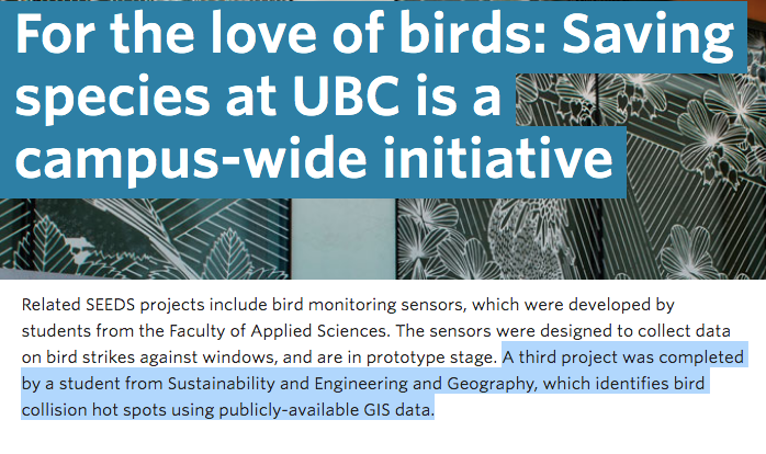
Image source: Cropped from original article.