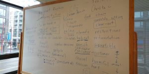
Feeling Through Conflict: A Reflective Activity for Planners and Designers
Feeling through Conflict is a guided reflective exercise I designed as a final project for my masters of planning course "Design and Planning for Community Power". I mobilized my skills in facilitation and storytelling to create an interactive worksheet for planners & designers engaged in anti-oppressive work.
Final Project – Chinatown Public Space Stewardship Strategy
Community engagement is an integral ingredient in planning decision-making. For my final project in my "Communication in the Face of Power" course as a Planning master student, I created a community engagement strategy and poster for a hypothetical project in Vancouver's Chinatown.
UBC Campus and Community Planning: UBC Bird Friendly Design Guidelines for Buildings
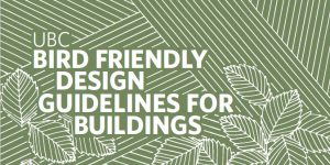
Over the last year, I took on a lead role in the writing and research for the updated UBC Bird Friendly Design Guidelines for Buildings. Through research of academic studies and best practice review of municipal guidelines across North America, the update promotes cost-effective and co-beneficial strategies to designers.
Research Abroad with TUDarmstadt: Seeing Soundscapes
In Summer 2019, I had the very enriching opportunity to collaborate on urban design research at Technische Universität Darmstadt, Germany as a visiting research student. I conducted a study to examine the relationship between soundscapes, urban design, and mental health and produced a research poster to illustrate my findings.
UBC Campus and Community Planning: The Green Building Action Plan
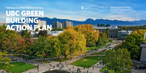
From Fall 2017-2018, I had the very exciting and unique opportunity to participate in writing and researching the new UBC Green Building Action Plan (GBAP) for UBC Campus and Community Planning. The GBAP outlines goals, targets, and actions to advance academic and residential buildings at UBC towards making net positive contributions to human and natural systems by 2035.
Final Project – Safer Buildings for Birds: a GIS Analysis
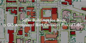
Buildings are the main anthropogenic cause of death for birds in cities, with approximately 16 to 42 million deaths in Canada each year, and around 10,000 deaths at UBC. To investigate this issue as a final project in my Advanced Issues in GIS class, I created a model to identify core institutional buildings of high bird collision risk at UBC. The project aims to recommend UBC operational staff where to target bird friendly design retrofits.
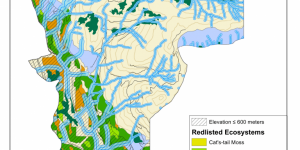
Advanced GIS: Potential Habitat Analysis for Spiranthes diluvialis
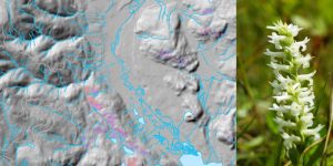
This week, I have been tasked to identify and produce a report on a rare plant species, Spiranthes diluvialis, to help a hypothetical botanist with her field work in the southern Okanagan. Using BC TRIM data, I create a digital elevation model and then use a multi-criteria evaluation methodology to map out ~700 hectares of potential habitat for the botanist to research.
Advanced GIS: Least-Cost Pathway for Marijuana Greenhouse
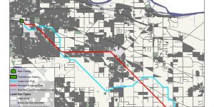
It’s been about over a year since I was first introduced to GIS, and I’m back to take GEOB 370 Advanced Issues in GIScience! In this lab assignment, I create a least cost path analysis for a hypothetical new marijuana greenhouse in Surrey and Langley, BC.
UBC Learning Exchange: Teaching & Learning as an English Conversation Program Facilitator
As an English Conversation Program Facilitator, I am responsible for preparing a lesson plan and guiding discussion for ESL learners on topics selected by the Program Coordinator. While I teach speaking skills, vocabulary, and pronunciation at the Learning Exchange, I'm also always learning from the patrons I meet as we exchange stories, skills, and laughs!
My ePortfolio Journey 2016-2018

Here is a timeline of my involvement with ePortfolio making and the UBC Arts ePortfolio program starting from my 3rd year GIS class to the present! This post will be updated as I continue to collaborate with the UBC Arts ePortfolio program.
Vancouver Aquarium: Educating and Interpreting the Wonders of the Sea!
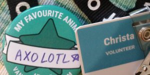
I have been a volunteer at the Vancouver Aquarium for 2 years as a Marine Educator and Gallery Educator. Find out how I engage visitors with facts and conservation takeaways about bamboo shark egg cases!
Final Project – Cultural Appropriation as a Spectrum
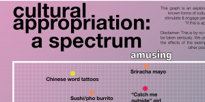
In order shed light on the complexity of cultural appropriation, I worked on a group project to present a variety of commonly discussed examples from popular media and daily life as a spectrum. Through the project, we hope to engage people to think beyond "is this appropriation?" to "if this is appropriation, who benefits and who doesn't?"
Cultivating Environmental Education in Downtown Vancouver
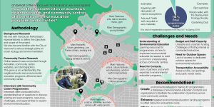
As a term-long project, I worked with a group of 4 students as consultants for the Vancouver Board of Parks and Recreation and CityStudio with the goals to: Investigate existing environmental education (EE) programming in community centres and identify opportunities for the Parks Board to expand them.
Documenting Asian-Canadian Experiences: Canra Sri Lankan Plus
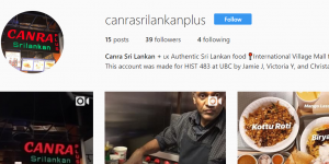
Food isn't just food, it's nourishment, culture, community, and a livelihood! This is the idea my teammates and I had in mind when we first started this project to document and narrate the stories of Canra Sri Lankan, our favourite food court stall in the International Village Plaza mall.
Documenting Asian-Canadian Experiences: Ombre- a Stop-Motion Animation
As the first assignment for my HIST 483 - Asian Migrations to the Americas class I was given the "simple" task of "representing a class partner in video, text, or sound". I chose to make a stop-motion draw-my-life style video! This assignment mostly gave us the chance to experiment with video-making and interviewing subjects for later assignments.
Final Project – Oregon Spotted Frog Recovery in BC
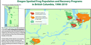
For the final project of my GEOB 372- Introduction to Cartography course, we were tasked to make a thematic map on any issue we were interested in. As a volunteer for educational programs at the Vancouver Aquarium, I decided to use my cartography skills to make an educational proportional symbol map that would summarize the current state of Oregon Spotted Frog populations and recovery programs in BC from 1998-2010.
The Makings of Cartography: Population of Non-Canadian-Official-Language Speakers
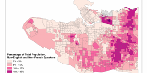
Using Canadian Census 2011 data, I create a choropleth map of non-English and non-French speakers in Vancouver on ArcGIS.
Final Project – Gentrification Risk Analysis in the City of Vancouver (Updated)
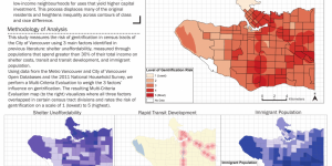
As the final project for my GEOB 270 Introduction to Geographic Information Sciences course, I work with three classmates to analyze and present a map of gentrification risk in the City of Vancouver.
Learning GIS: Environmental Assessment of Garibaldi Project
In this assignment, I have been tasked with performing an environmental impact assessment of the proposed Garibaldi resort in Squamish.